skip to content
Current Lead Times: Simple-Custom Framesets: 1 week. Full Custom Bikes: 7 weeks.

U.S. Built Custom Bicycles in Titanium and Titanium-Carbon Mix

On the Road: Zand Martin Cycling the Russian Altai

Last week, we saw the set up for Zand’s expedition. This week, we’re underway.

The Altai Mountains are quite probably where skiing was conceived, not in the modern form we know, which originated in Scandinavia, but in a more elemental way, practiced by the indigenous people of Central Asia. Zand’s expedition sought out some of the terra prima of skiing, but approached all the overland travel by bike. To get into the mountains, Zand and his partner first had to ride the Chuysky Trakt. Zand’s own words below.

This road, the Chuysky Trakt, was cut through the mountains in the 1930s by gulag inmates, and runs 1000km from the Trans-Siberian Railroad to the Mongolian border. We began in Gorno-Altaisk, the capital of the semi-autonomous Altai Republic, and will steadily gain elevation until we reach the highlands of Mongolia.

Across the pass, we push bikes along a snow drifted ribbon of cracked asphalt to the half-abandoned Soviet-era ski base atop Seminsky. We nearly missed it in the low cloud, but on emerging from the ail, the sun had made an effort and a few cuts were revealed on the mountainside.The road drops down and we find our way over plateau and valley back to the Katun, and a cold, dry steppe climate. The road is good, and easy to navigate: if you leave the spiderwebbed asphalt, you are going the wrong way. This 500 kilometer line runs through the heart of the range, and we follow it over passes and through small log villages clustered around shingled rivers.

Confederations of sheep and goats wander thawing hillsides under the occasional watch of dog and motorcycle-borne shepherd. Cows and pigs march the paddocks closer to home, though the pigs fade from prominence as we transition to a Muslim minority in the mixed ethnic map of Russian, Altai, and Kazakh. The Altai here is religiously diverse, with Russian Orthodox, Islam, Tengrism, Tibetan Buddhism, and less organized belief systems often called Shamanism, but really more a blend of animism and ancestor reverence.

As we leave the Katun Valley for the last time and begin to ascend the Chuya, we pass our last church in Aktash village and enter the Chuya steppe, a dry, barren, high altitude grassland hemmed in by mountains. Entering the frontier town of Koch Agash, we pass our first mosque, a humble green timber affair with a crescent moon of beaten sheet metal on the peak of the hall.

Here, we plan our first extended foray into the mountains.

On the Road: Zand Martin in the Altai Mountains

Zand Martin is an explorer. You met him here prior to this expedition. “Circling the Golden Mountains” is an attempt to circumnavigate the Altai by ski and bicycle and to tell the story of this region, its people and landscape, to as wide an audience as possible.

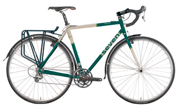
We outfitted Zand with an Expat S backcountry touring bike, which, as you’ll see, he packed with skis plus everything he might need to live in the wilderness for weeks at a time. Here are some photos from his trip prep, and some brief words about his plans.

We intend to trace a 4,000-kilometer route through Kazakhstan, China, Mongolia, and Russia, and to carry skis on our bicycles and execute between two and three dedicated multi-day ski tours in each country, with peak ascents and roadside missions as spring advances. We hold an absolute dedication to a light, fast, and low-budget aesthetic, and unless we hold to this style throughout, the route will not be possible.

When I first started running my own expeditions, sourcing maps was one of the most intimidating details for me. If you want to hike in the White Mountains or paddle in Maine, you can probably get by with an atlas and gazetteer, or a swing by a local outdoor store for a specialty map. Kazakhstan, rural France, or even more distant places in North America would at first seem impenetrable  without the right tools, and a novice could have trouble finding those tools. To be clear, I am talking about paper maps. The ability to read terrain and landmarks, and associate them with features on a topographic or physical map printed on paper is the key skill in expedition navigation, both in the front country and the wilderness.

Watch this space for more installments and gorgeous photos from Zand in the Golden Mountains, the Altai.


Don’s Expat S

As the northern hemisphere heads toward winter, we find ourselves building a lot of specialized commuter bikes, and it seems that each region, according to the severity of its climate has its own preferences for commuting comfort. There is so much we can do to personalize a bike, and commuter bikes tend to be hyper-personalized, so that they become some of the most interesting projects we work on.

Our friends at Outdoors, Inc in Memphis helped us put this one together, a super commuter based on our Expat S platform.

Note the Tiberius handlebar, the bead blasted “decals.”