
It’s been a hard couple of years on the bike for Pamela Blalock. In June of 2013 she was hit head on by another cyclist coming at her on the wrong side of the road, breaking her collarbone. Then, three months later she was hit by a truck, from behind. The resulting surgery left her with fused vertebra and, ironically, a whole litany of titanium screws and supports. She broke six ribs and spent four months in a back brace. She got back on the bike last April, but has been doing physical therapy and dealing with chronic pain continuously since then.
By the time she and John got to Ireland this year she had missed a lot of saddle time. In fact, the last of their annual trips to John’s homeland, she’d spent the whole time walking mile and miles through Dublin’s rambling streets and urban parks. She had dreamed of getting back on her bike. This year, getting from Dublin to the west coast, where they’d not been in nearly twenty years, was something of a redemptive pilgrimage for her, each ride a rich reward for pain endured and time passed.
In Scotland, the lakes are lochs, the most famous of which is Loch Ness, with its deep, dark water and its monster. The Irish equivalent is a lough, and the west of the country, Galway and Connemara are marked by two massive inland lakes, Lough Corrib and Lough Mask.
This photo was taken from the road above Lough Corrib. Old stone walls cut the farm fields into grazeable portions for the local sheep.
This is the road down to Lough Mask. Rolling banks of gray clouds hint at the sudden and torrential rain that leave you feeling you earned whatever view the day afforded.
This is the grass-corrupted double track to Westport in Connemara during a brief spasm of sun. These roads all rise and fall like the country’s erratic heart beat.
Here is the dark and wet portion of the Westport loop, fluoro vests keeping the riders from disappearing into the slate gray day.
The Sheeffry Mountains (the Irish translation is “Hills of the Wraith”) in County Mayo offer cyclists miles of these rough, narrow roads. This shot, taken in Sheeffry Pass, captures the elemental nature of riding in Ireland.
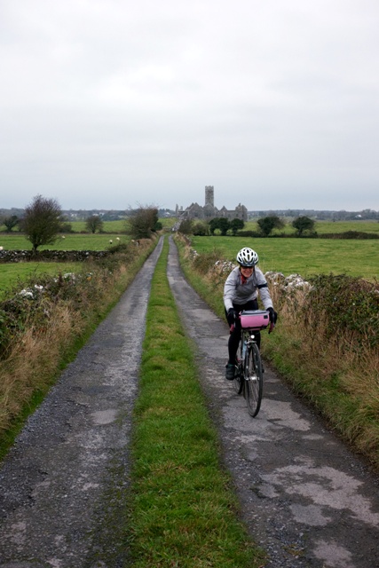
This the road from Ross Errilly Friary in County Galway, a medieval Fransiscan outpost among the oldest and best preserved such structures in Ireland.
The River Bundorragha south of Fin Lough, popular with fly-fishermen.
This is Kylemore Abbey, a 70 room castle built in the 1870s, by a wealthy London doctor. It sits in western Galway on the shore of Lough Pollacapall. It was converted to a Benedictine Monastery in the 1920s. Today the estate is surrounded by walled, Victorian gardens.
The Sky Road, west of Clifden, Connemara, Galway. On a clear(er) day, the Sky Road overlooks Clifden Bay and its offshore islands, Inishturk and Turbot.