skip to content
Current Lead Times: Simple-Custom Framesets: 1 week. Full Custom Bikes: 7 weeks.

U.S. Built Custom Bicycles in Titanium and Titanium-Carbon Mix

On the Road: Zand Martin Cycling the Kazakh Steppe

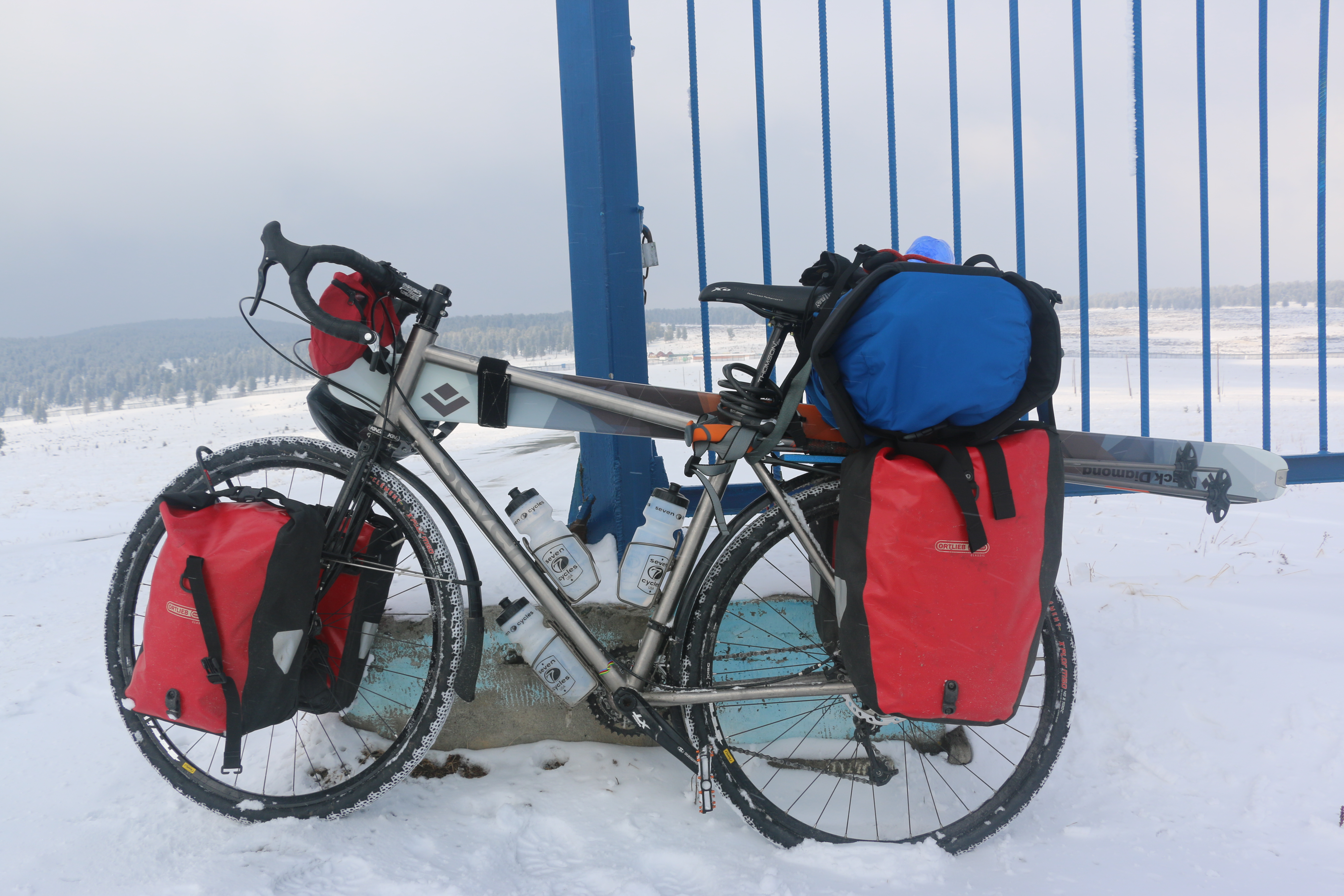
It’s a long time since Zand Martin came to pick up his Expat S and laid all his Russian military maps on the floor in our showroom to show us what he had planned. Over the course of the expedition (see here, here, here, here, here and here), we saw things go awry and askew as some of those maps failed to reflect a workable reality for Zand and his expedition partner. And yet, they managed to see and document so many of Central Asia’s beautiful, seldom-seen locales, and we couldn’t have enjoyed seeing those landscapes more, one of our bikes a tool that helped bring back those views.

Our On the Road series is about showcasing what riders are doing with our bikes out in the world. Zand is a different kind of rider, a true adventurer and explorer, and we count ourselves lucky to be able to share his stories with you here.

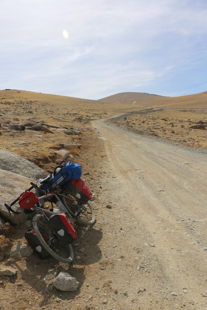
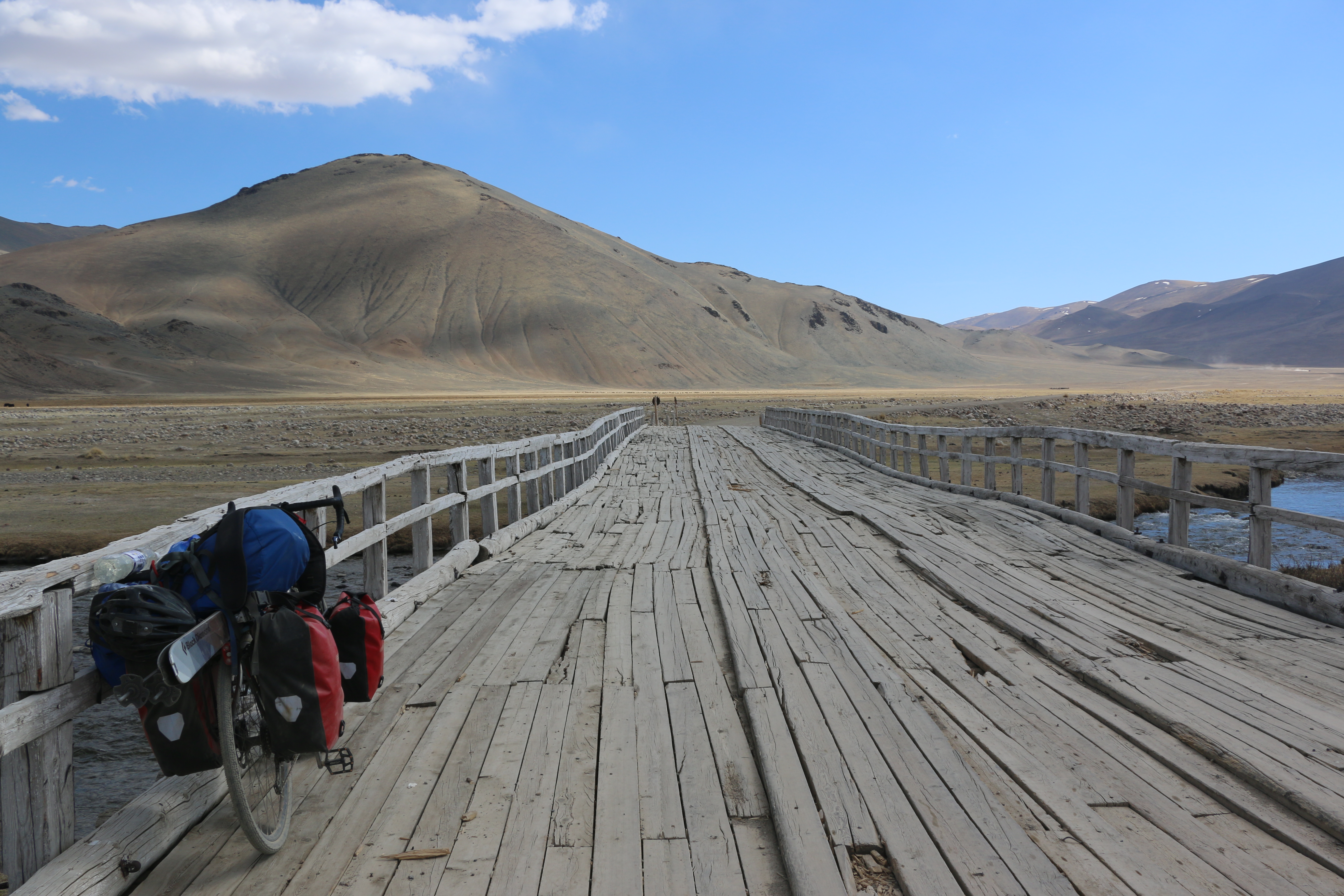
More of Zand’s lovely photos and prose below:

The road has no outlet. There is no bridge, and no ferry. The map is wrong, again. We are crushed, again. We followed the main road towards Ust-Kamenogorsk as our map had it, along the shores of the great reservoir of Bukhatarmskoye. But twenty-five kilometers from anywhere, the road turns to dirt and a branch drops to a languid shore and a rusted, abandoned ferry dock. The family smoking cigarettes on the dock offers us candy and cabbage rolls, and confirms our suspicions, pointing north to the road. “Nyet parom, nyet most,” no ferry, no bridge between here and Ust-Kamenogorsk, Oskemen in Kazakh. They indicate a barge in the lake, the ferry coming to take them west across to a road that leads to Samara. It is 240 kilometers to our railhead by that route, and when the boat docks and disgorges a small truck and two Ladas, we reluctantly wheel our bikes on board.

We had taken a leisurely lunch, knowing we would camp the night by the reservoir and then have an easy morning into Ust. There, we would reach the railhead and the end of our human-powered journey around the Altai. We were fifty kilometers away, after thousands. Moments before we were exultant, our ending close and within the easy reach of a morning’s ride. Now, we are again cast into uncertainty and high challenge. We sullenly eat crackers on a bench by the railing. A trio of weathered Russian and Kazakh men loosen the steel cable loops on the ship-side bollards, and the Odessa slips out of the dock into the narrow reservoir.

We had spent almost two weeks in the watershed, both in China, the mountains along the Austrian Road, and down in the rolling Kazakh steppe along the rivers draining to the Irtysh. Leafy villages dotted our route through the grasslands, simple settlements following a comfortable pattern: spread a handful of shops and markets along the main road, and cluster log and concrete brick houses around it with gardens and hayricks. Every town has a mosque built since the fall of the Soviet Union, often including Timurid and Persian elements like blue tile domes and large brick arched entrances. They are village affairs, humble, and tell the story of Islamic revival in Kazakhstan, encouraged from within the country, and from without.

We relish the sparse green of the villages, and eat ice creams on rickety benches while schoolchildren ask us our name and giggle at our strange accents. In Russian-influenced and settled Kazakhstan, we added cheese and butter back into our diet, along with tomato sauce and real ice cream bars. The wind, unfortunately, continued to plague us until the asphalt ran out on the outskirts of Terekty, and that new challenge gave us a reprieve until we finished the Austrian Road and returned to sealed roads. There, we pass between the mountain walls headed west. North, Siberia begins, while south, whence we came, Central Asia stretches in desert, and glacier. The wind assaulted us, again. We moved west through verdant pasture, crawling into a forty knot headwind for the tenth day. Our first night camping beyond the Austrian Road, we hide behind poplars and wake to several inches of snow. At the latitude of Seattle and the elevation of Pittsburgh.

As we near the far shore, the captain waves us up two stories to the wheel house. The sparse bridge holds a few notebooks, a throttle marked in stenciled Cyrillic, and a great wooden ship’s wheel. He shows us the controls, and jots down distances to our next town: seventy kilometers. We dock as the sun drops, and move a few kilometers on to a rise above the lake. We set tents, boil water, and settle in to our disappointment and our well-exercised muscle of moving on, laughing, and planning. In the last light, two Kazakh horsemen wander by from work in the hills along the lake. We chat, and before leaving one dismounts and urges me into the saddle. Reminiscent of childhood pony rides, the second shepherd holds my reins and we ring camp at a trot.

Of course, there’s more worth reading and seeing on Zand’s expedition 7. Check it out.


On the Road: Zand Martin Cycling the Kazakhstani Altai

Look at a map of Central Asia and find the intersection of Russia, Mongolia, China and Kazakhstan. That’s where Zand and his partner are traveling, where the dots that represent cities and towns get fewer and farther between. In this installment of Zand’s adventures Circling the Golden Mountains, they enter Kazakhstan from China.

Read about the beginning of this journey here, here, here and here. As usual, find his images and journal from the trip below:

“Can you see the bridge?” Brian shouts down to me. A moment of confusion and elation pass between us. I am on the cobble marge of the Kara Koba, washing dishes from dinner with water from the stream. It is achingly cold, running fast over a polished, rocky bed. I face upriver, and below the obscuring larch and birch, I spot a span of rusted box girder. Brian sees my face, and knows what my lightbulb expression must mean.

An hour before, we had stood at the old bridgehead and watched the track run out into space. Nearby a ford roared with the freshet, and we discussed our options for the crossing. The creeping shadow line of evening encouraged dinner, sleeping bags, and procrastination until morning. With no way across the river, we were crushed, again. Two kilometers of drifted switchbacks had filled our afternoon, depositing us on the floor of the valley wet to the waist and covered in mud. Rolling out of the snowbound forest, slush dropped from spokes and racks, and we moved into sun, leaving a postholed, pannier-plowed track behind.

Now, our deliverance appears right under our noses, and we jog up to the bridge and walk out on rough milled planks wired to ancient steel. Clear snowmelt runs below, wrapping rocks in foam and racing out of the gorge above: tomorrow’s work. The way seems clear, for this moment only, and we are giddy that another puzzle piece has reluctantly found its place.

This track, once a road, was built between 1915 – 1917 by Austro-Hungarian prisoners captured on the Eastern Front in the Great War. They toiled in these remote mountains at the edge of the Russian Empire, thousands of miles from the fighting. They cut this rough track through the mountains with shovel and pickaxe, rope and saw, bridging the Kara Koba five times in the wild gorge just upstream from us. They connected the valley of the Burkhtarma, once the northern route on the great Silk Road, with China and the basin of the Cherny (Black) Irtysh.

For their achievement, the track is still called the Austrian Road. The Czech, Slovak, Austrian, and Hungarian prisoners who labored in this remote wilderness left no trace save the occasionally level path cut into the hillside and over these successive passes and gorges. They worked and died as two empires collapsed around them: their own, and that of their captors. As the storm of revolution broke in 1917, this small work gang was surely caught in the middle. Were they repatriated by Trotsky in time? Or did they join the Czechslovak Legion in its long fight from Europe to the Pacific, and race the nascent Red Army along the Trans-Siberian Railroad in armored trains bound for Vladivostok and Allied evacuation to America? No one knows.

We left China in storm and wind, hoping our way would be smoother in Kazakhstan. Things did not start well. We were held at the border for seven hours as Chinese officers looked through the photos on our cameras and the Kazakhstan guards asked us about Jessica Alba, our homes (“Please tell us one thing your state is known for.”), and our plans for their illustrious country. All this, before they informed us our visas are fake and we cannot enter the country – Kazakhstan does not issue five-year visas to Americans. Except that they do. Once the immigration office in Astana finished its three hour lunch break, they informed our erstwhile captors that the rules had changed last year, and to let us go. One would think knowing current visa rules would be a top priority for boarder guards.

We followed the border fence north. The wind hounded us until the road turned to dirt and began to climb. The thousand-foot dunes of the Ak Kum desert (‘white sands’) reflected bright sunshine behind, and as usual the land gave no shade. We sweat, and salty Rorschach lines grew on shirt and hat as sandy gravel switchbacks turned desert to steppe, then to scrub and subalpine meadow. The air cooled as the road climbed, rising 3200′ in under ten kilometers, making it a bit steeper than the Mt. Washington Autoroad with a worse surface condition. Beyond the Mramorniy Pass, we rolled over the White Pasture of Akzhailau and ascended a second pass, Tikkabak, where conifers appeared and we caught our first glimpse of mountains wreathed in snow.

In this exertion, we worried about our border permits. We had arranged for them to be processed in February, but our contacts had failed us spectacularly and only informed us a few days before we entered the border zone that we did not actually have permission to be there. Our afternoon cycling along the actual border fence was one of worry and uncertainty, but as we climbed we committed ourselves to this route; it would add 350km to go back and around the mountains. With every checkpoint, police jeep, and document request, we escaped unstopped, still, miraculously, fixed on our goal. The rangers, soldiers, police, schoolchildren, horsemen, and shopkeepers that asked us our route all nodded, some pointing back the way we had come, saying the road disappeared if we went north long enough. Beyond the great lake of Markakol, a park ranger pulled his jeep over to tell us the Austrian Road would be impassible and we wont reach the Burkhtarma. When we insist, he smiles and wishes us good luck. We have found, so far on this trip, that everyone is nearly always wrong, and the only way to know what lies ahead is to go and have a look for yourself. If there are any grains of truth in their advice, they will reveal themselves.

A kilometer later, the next bridgehead appears, with the girders swept parallel to the far shore with planks sloughed off into the current twenty feet below. The mountainsides drop to the river in mixed meadow and taiga, and we scout the left bank, sure of our forward momentum. In two hours of heavy lifting, we portage along cliff bands and over frozen avalanche debris, walking in the river when necessary. The third bridge stands, repaired at some point with sawn telephone poles still sporting their wire hangers. On bridges four and five, the planks are gone, leaving only the bent, rusted girders, and we engineer solutions our mothers are encouraged not to ask us about. In nine hours of extreme effort, we make eight kilometers.

The track is mud, rock, and snow. It rises against mountains now considering spring in carpets of wildflowers, European globe-flowers and irises purple and yellow, ruthenica and bloudowii. Snowfields beckon above forest bands, but with such a slow day, our food won’t last and we are wary of what slow, grinding hardship will present itself on the morrow. The skis stay on the bikes, but we stop from time to time and gaze up at the ridges still holding their snow, at the Sarymsaty (‘Garlic’) Ridge, and onwards to Burkitaul and Aksubas Peaks, ‘Eagle’s Eyrie’ and ‘Head of White Water’, respectively.

The land is stunning, and utterly empty in this season. There is no one in the valley of the Kara Koba, the last mountain village of a few hundred nearly two days behind. We soak in the green, white, and blue, the moisture of a clean, alpine landscape. The steppe worked us, but here, despite the absurd physicality of the travel, we are revived. Cresting our last high point the next morning, we are confronted by the valley of the Burkhtarma. This is the Burkhatskiy Pass, and, along with the Tarbagatay Ridge, marks the vague, shifting ecological boundary between Siberia and Central Asia. To the north, we see Russia and Belukha, the great glacier-clad peak at the heart of the Altai Mountains. Three thousand feet below, the valley opens and we see the arrow-straight asphalt ribbon that will connect us again with civilization.

For even more from Zand about his adventures in the Golden Mountains, the Altai, check out his 7 from the trip.

Check out the bike Zand rode on the trip.


On the Road: Zand Martin Cycling the Chinese Altai

Checking back in with Zand Martin as he and his expedition partner stalk the Golden Mountains, the Altai, of central Asia. Below, more of Zand’s photos and his luminous prose.

We make certain assumptions when looking at a map. It is a designed object, the recipient of refinement, and bears a certain authority in its geometry. But despite the weight of accumulated knowledge they exhibit, maps are not infallible. The person who designed our map of Xinjiang lives, I believe, in Budapest. I don’t think this person has ever been to this lonely spot in north China, but they created a layered image representing it that was then printed, and is now in a plastic bag in my hands flapping a tih-tih-tih staccato around my thumb and forefinger.

I am in a town that doesn’t exist, and on a road whose route is deviant from the world as known to our Hungarian cartographer. In this barren stretch, we rely on sparse settlements to restock. Beyond the kilometer marker where our village should be, an empty valley of rock, sand, and scrub stretches to the horizon. This is our third phantom village today, and evening has begun to draw the curtain on our misfortune. The road is not right, and the towns we expect for food and water do not exist.

We camp behind a low brown hill, and use our last water to cook our last food. I find a scrap of rug fallen from a camel train and set it before Brian’s tent as an entry way to lighten the mood. I find a scorpion on it as I set it down, spoiling the gift.

The wind rises at 1AM, and we lose our sleep wondering if the tents will hold. They do, and at 6AM we move to the road and encounter an early morning resumption of the previous days direct, soul crushing headwind. Today it is stronger, and has come earlier.

With eighty kilometers to the next settlement and no water in bottles or landscape – not a drop to the horizon – we flag down a truck and are whisked into Beitun. I can think of no other activity comparable to cycling into a 35 knot wind. It is soul crushing. You can still crawl along without much risk, but it is excruciatingly difficult and slow. There is no rhythm. In this land, there is no where to hide and it roars in your ears the whole day long.

The steppe is utterly empty until we reach the abrupt edge of downtown. Our map uses font size to indicate settlement size. Beitun is marked as being the same size as Saribulak, one of the towns that did not exist. In reality, Beitun has 90,000 people in a compact city of modern buildings, leafy avenues, hotels, markets, and restaurants. It is the opposite of the countryside in every way.

Beitun is brand new, and under construction. It speaks of recent Han colonization, of a risen China appropriating its ethnic periphery and casting a web of super modern infrastructure across a landscape unaccustomed to such attention.

There is MUCH more to this story.  Read herehere and here for our own past installments, or visit Zand’s expedition 7 for the full text and even more photos. Zand rides an Expat S, built to carry everything he needs over months adventuring in the farthest flung wilderness Earth has to offer.

On the Road: Zand Martin Cycling the Russian Altai

Last week, we saw the set up for Zand’s expedition. This week, we’re underway.

The Altai Mountains are quite probably where skiing was conceived, not in the modern form we know, which originated in Scandinavia, but in a more elemental way, practiced by the indigenous people of Central Asia. Zand’s expedition sought out some of the terra prima of skiing, but approached all the overland travel by bike. To get into the mountains, Zand and his partner first had to ride the Chuysky Trakt. Zand’s own words below.

This road, the Chuysky Trakt, was cut through the mountains in the 1930s by gulag inmates, and runs 1000km from the Trans-Siberian Railroad to the Mongolian border. We began in Gorno-Altaisk, the capital of the semi-autonomous Altai Republic, and will steadily gain elevation until we reach the highlands of Mongolia.

Across the pass, we push bikes along a snow drifted ribbon of cracked asphalt to the half-abandoned Soviet-era ski base atop Seminsky. We nearly missed it in the low cloud, but on emerging from the ail, the sun had made an effort and a few cuts were revealed on the mountainside.The road drops down and we find our way over plateau and valley back to the Katun, and a cold, dry steppe climate. The road is good, and easy to navigate: if you leave the spiderwebbed asphalt, you are going the wrong way. This 500 kilometer line runs through the heart of the range, and we follow it over passes and through small log villages clustered around shingled rivers.

Confederations of sheep and goats wander thawing hillsides under the occasional watch of dog and motorcycle-borne shepherd. Cows and pigs march the paddocks closer to home, though the pigs fade from prominence as we transition to a Muslim minority in the mixed ethnic map of Russian, Altai, and Kazakh. The Altai here is religiously diverse, with Russian Orthodox, Islam, Tengrism, Tibetan Buddhism, and less organized belief systems often called Shamanism, but really more a blend of animism and ancestor reverence.

As we leave the Katun Valley for the last time and begin to ascend the Chuya, we pass our last church in Aktash village and enter the Chuya steppe, a dry, barren, high altitude grassland hemmed in by mountains. Entering the frontier town of Koch Agash, we pass our first mosque, a humble green timber affair with a crescent moon of beaten sheet metal on the peak of the hall.

Here, we plan our first extended foray into the mountains.

The Making of an Expedition Bike

Sola SL ready for bikepacking

When Zand told us he was packing as light as possible, we didn’t think he meant to carry a hundred pounds of bike and gear. Skis, ski boots, poles, avalanche gear, camping equipment, cooking utensils, cameras, and other odds and ends apparently add up pretty quickly. Once the trip began, Zand reported that the total outfit weighed in at almost exactly one hundred pounds. Not bad, if you’re going downhill, but something about circumnavigating the Altai Mountains suggested there would be some uphill too.

rider getting fitted

Every tube that makes up his Expat S, and every other Seven as well, is carefully selected and tailored based on the rider and how they mean to use their bike. Zand’s bike was unique because it was designed around three total extremes; the giant size of the frame, the massive amount of gear it would haul, and the intricate details required to handle the rigorous conditions of the Altai. Each Seven is unique, but to have three far out requirements made for an especially fun project.

Zand is a tall guy, and lean. His Seven stands like a mammoth next to most bikes, but the 29″ wheels make it look proportional. Normally someone will take a completed bike for a spin to check their handiwork first hand, but the saddle height on Zand’s Expat S was far above what any of us was comfortable straddling. We left the test ride to Zand himself, and the big fella made the bike look great, a perfect fit.

Selecting the tube set for this frame was a challenge. As we said, Zand is tall and strong, but slim. If we were designing him a road bike, he might prefer the cushy road feel of smaller diameter tubes. But on an expedition bike, set to carry a huge load, a smaller diameter tubeset would likely bend and flex too much, making for an inefficient ride. To ensure this bike would ride well under weight, we used larger diameter tubes which flex less, adding to the frame’s stability.

Seven on a long dirt road

Designing a bike to fit a tall rider, and making sure it was sturdy enough to carry all of the required provisions proved to be manageable, but how could we design a bike for the unknown trail ahead?

Adjustability.

As an example, we discussed what tires he thought he’d use. The surfaces that he knew he would ride on were paved roads, unpaved roads, destroyed roads, dirt trails, and each of those covered in snow as well. Much of the route was unknown however, so we started with 40mm knobbies, but left room for a two inch tire, just in case. We chose straight gauge tubes, not that butted tubes aren’t strong, but the thick walls of a straight gauge tube will provide that much more impact resistance in the case of a crash. Descending unknown mountain roads in variable conditions suggested crashing was a possibility. Rack and fender mounts were obvious additions, as was a chain hanger to ease repairs, and the low mount disc brake that helps keep each of these areas free of frame clutter.

At this point, just 230kn to the finish, Zand’s trip, and his Expat S have seen their fair share of adventure, and challenges. But both continue to impress. Best of luck on the final push, Zand!
Seven on the expedition